The Ontario Building Code references NBCC 2020 for geotechnical design, and in Peterborough’s glacial terrain, slope stability analysis is not a box-ticking exercise. The drumlin fields south of the city and the deep Otonabee River valley create cut-slope conditions that vary dramatically within a single property. Our laboratory has processed hundreds of samples from the Haliburton-Peterborough contact zone, where dense till overlies limestone bedrock at shallow depth. When a grading plan calls for 4:1 slopes, the assumptions need ground-truthing. We run direct shear on undisturbed Shelby tube samples, measure residual strengths on the clay fraction, and check pore pressure response under saturated conditions. The triaxial testing program provides the effective stress parameters that go directly into the stability model, and we often pair that with grain-size analysis to confirm whether the till matrix behaves as well-graded or gap-graded material.
The weathered-unweathered interface in Port Hope till controls most shallow slope failures in the Peterborough drumlin region.
Scope of work in Peterborough Ontario
Demonstration video
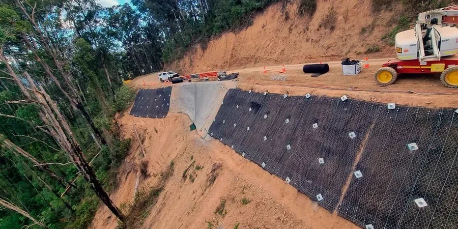
Critical ground factors in Peterborough Ontario
Our field crew deploys a track-mounted CPT rig on the actual slope face whenever access permits, pushing a 15 cm² cone with pore pressure transducer through the full weathered profile. The friction sleeve data maps the transition from crust to intact till with centimetre precision, and the dissipation tests tell us how fast the perched water drains after a storm. Back in the lab, the Bromhead ring shear apparatus runs on the clay fraction at very low displacement rates to measure residual strength—the value that governs reactivated landslides. Peterborough sits in seismic zone 2 per NBCC, so the pseudo-static analysis adds a horizontal acceleration of 0.05g to the limit equilibrium model. That number looks small on paper, but on a 20-metre-high slope with marginal factor of safety, it often controls the design. The report includes both circular and block-type failure searches, because the limestone bedrock contact acts as a pre-defined failure surface that planar block analyses capture better than circular methods.
Our services
Every slope in Peterborough tells a different story depending on its orientation, the till facies, and the groundwater regime. Our stability analysis packages are built around the specific failure mechanisms that matter here.
Limit Equilibrium Modeling
We run Slide2 and SLOPE/W models using lab-measured strength parameters, not textbook values. Each model includes circular, block, and compound failure searches, with sensitivity analysis on the weathered-unweathered boundary position.
Groundwater Monitoring for Slopes
Standpipe piezometers installed in the slope face capture seasonal water level fluctuations. We correlate pore pressure data with precipitation records from the Trent University weather station to build realistic phreatic surfaces for the model.
Remedial Design Support
When the factor of safety comes in below 1.5, we provide back-analysis parameters for flattening, toe berms, or drainage solutions. Our lab verifies the shear strength of imported granular fill for buttress construction.
Construction-Phase Verification
We visit the cut face during excavation to confirm that exposed stratigraphy matches the model assumptions. If unexpected soft layers appear, we re-run the analysis with revised parameters before the next bench is cut.
Common questions
How much does a slope stability analysis cost for a typical residential lot in Peterborough?
For a single-lot development on a sloping property in Peterborough, the analysis typically ranges from CA$1,570 to CA$5,090 depending on the slope height, access conditions, and how many soil horizons need laboratory strength testing.
Do I really need a stability analysis for a slope that has been stable for 30 years?
A slope that has stood for three decades can still fail when conditions change. The weathered crust of Peterborough till slowly loses strength over time as clay minerals hydrate. A new cut at the toe for a foundation, a wetter-than-average fall, or removal of vegetation that previously provided root reinforcement can all reduce the factor of safety below the NBCC minimum of 1.5 without visible warning signs.
How long does it take to get the stability report after drilling?
We typically deliver the complete slope stability report within 3 to 4 weeks after completing the site investigation. Direct shear and triaxial tests require time for specimen preparation, saturation, and shearing at controlled rates. Ring shear residual testing on the clay fraction adds about one extra week because we shear at very low displacement rates to reach the true residual condition.